AUTHOR’S THESIS
By Altanbagana Baatar
DBA Candidate| Independent Historian
ImperialGG Historical Research Seriers
21 October 2026
THE TOPOGRAPHY OF DEFEAT: WHY THE MOGOD–NOMGON RANGE BETTER EXPLAINS THE BATTLE OF NAQU GUN
1. THE CENTRAL QUESTION: WHICH LANDSCAPE EXPLAINS THE TEXT?
The location of the Battle of Naqu Gun should not be determined solely by the resemblance between an ancient place-name and a modern mountain. The decisive question is whether the physical landscape can account for the sequence of military movements and the extraordinary description of the Naiman defeat preserved in The Secret History of the Mongols, particularly §§195–196.
Two principal geographical interpretations deserve comparison. The first associates Naqu Gun with Lakh Mountain in Dashinchilen soum, Bulgan aimag. The second identifies Naqu Gun with the Nomgon range in Mogod soum, in the wider Mogod–Tashir mountain landscape. A published discussion of the debate argues that the Lakh Mountain identification encounters difficulties involving distance, the relationship to the Orkhon River, and the absence of terrain features capable of explaining the reported mass fall. It proposes the Nomgon area as a more plausible alternative. These arguments provide a basis for further analysis, rather than an uncontested final determination. <Cite refs={[“turn199415view0”]}/>
The author’s thesis is that the Mogod–Nomgon landscape offers a stronger geographical explanation of the events in §§195–196 because its relationship between open pasture, mountain approaches, steep slopes, and potential escape routes appears more consistent with the narrative than the terrain attributed to Lakh Mountain.
2. SAARI KHEER: THE OPEN PASTURE BETWEEN LAKH MOUNTAIN AND NOMGON
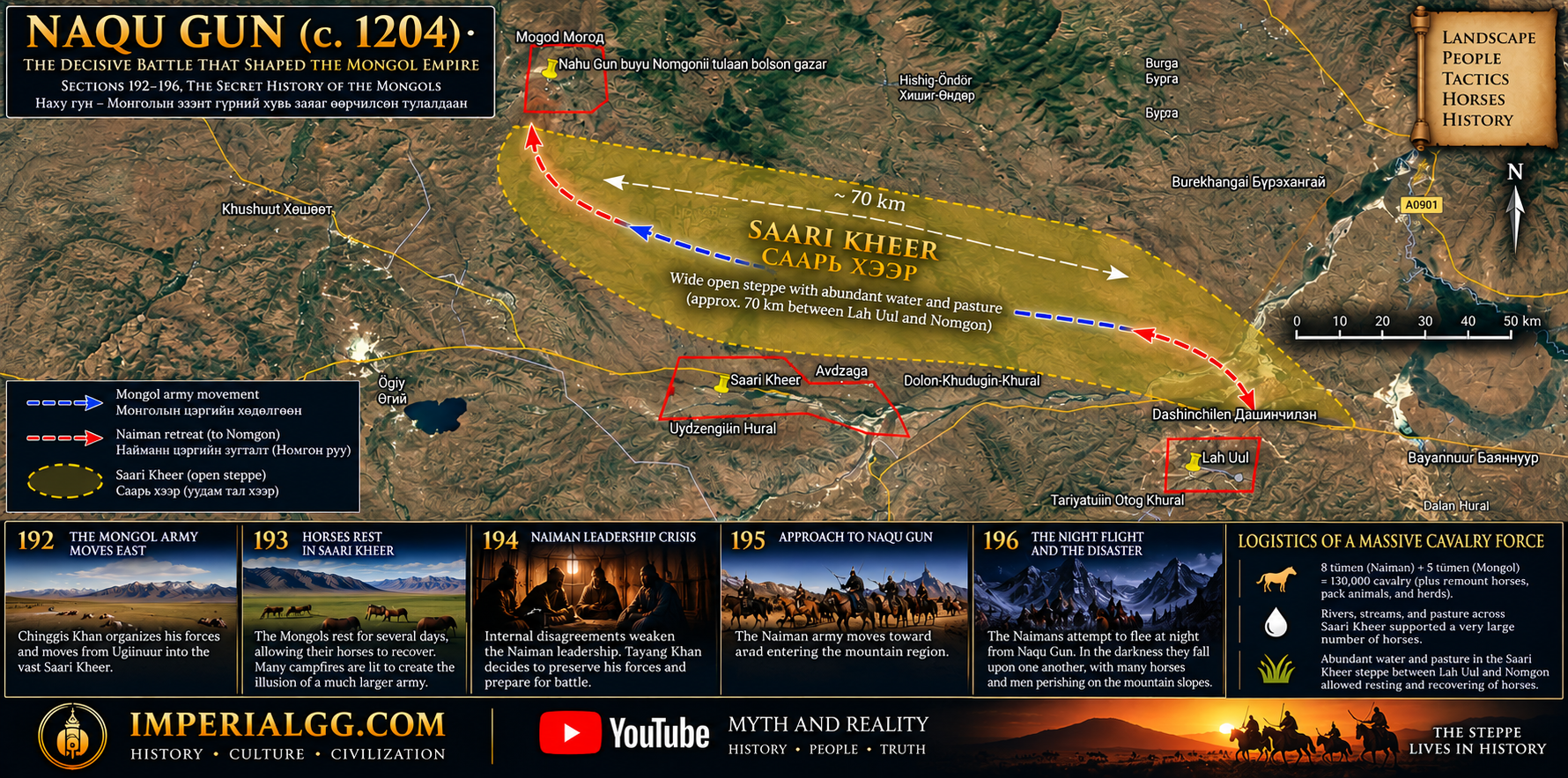
Saari Kheer should be examined as a broad geographical landscape, not necessarily as a single, narrowly bounded point on a modern map. In the author’s local geographical interpretation, it is the approximately 70-kilometre-wide region of open steppe between Lakh Mountain and the Nomgon range, characterized by streams, water sources, and extensive pasture suitable for horses and other livestock.
This landscape is important to the events of §193. Chinggis Khan’s army has travelled a considerable distance, and the narrative describes a decision to halt, allow the horses to feed and recover, and use numerous fires to make the Mongol force appear larger than it was. Such a tactic presupposes a place where a mounted army could spread out, maintain its animals, establish temporary camps, and create a conspicuous display visible to enemy observers.
The broad pasture between Lakh Mountain and Nomgon provides a plausible environmental context for this episode. Its significance lies not merely in its size but in the relationship between open grazing land and the mountain terrain beyond it. The open steppe could accommodate the Mongol encampment, while the surrounding ridges and elevated positions could provide observation points and constrain the movements of an opposing force.
This identification of Saari Kheer is the author’s geographical interpretation, informed by local knowledge and comparison with the narrative. Its historical boundaries should not be treated as definitively established without further toponymic and documentary evidence.
3. TAYANG KHAN’S MOVEMENT TOWARD THE MOGOD–NOMGON AREA
Section 195 describes Tayang Khan’s decision to fight after the disagreement within the Naiman leadership. The Naiman army moves from Khachir-Us toward the Tamir River, crosses the Orkhon, and proceeds toward Naqu Gun and Tsakhir Mogod. This sequence makes the relationship among the rivers, the mountain ranges, and the intervening pasture central to locating the battlefield.
The Mogod–Nomgon interpretation seeks to reconstruct this movement as a connected geographical sequence rather than treating each place-name independently. The Orkhon crossing, the approach to the Mogod–Tashir mountain landscape, and the position of Nomgon must all be considered together. A published argument identifies the Orkhon crossing at Dertsiin ford as a possible route and proposes that the modern Mogod–Tashir ranges correspond to Tsakhir Mogod, with Nomgon as a candidate for Naqu Gun. <Cite refs={[“turn199415view0”]}/>
Within this reconstruction, the Naiman movement toward the mountain range is not simply a retreat across an undifferentiated plain. It is movement into a landscape where the direction of approach, the configuration of ridges, and the availability of passages could influence the options available to an army under pressure.
4. SECTION 196: THE NIGHT FLIGHT AND THE TOPOGRAPHY OF MASS CASUALTIES
The most significant geographical evidence appears in §196. The account describes the Naimans attempting to flee at night from Naqu Gun. As they descend or slip from the mountain, they fall upon one another, suffer severe injuries, and die in a mass of bodies. The passage conveys not an ordinary withdrawal across open ground but a catastrophic movement in darkness over hazardous terrain.
This description establishes a demanding test for any proposed battlefield location. The landscape must plausibly account for several conditions: a large body of soldiers and horses moving at night; limited visibility; disorder during a retreat; steep or unstable ground; and the possibility that those in front could fall or lose their footing, causing those behind to collide with or fall upon them.
The author’s argument is that the terrain of the Nomgon range and its surrounding hills deserves particular attention because its ridges, steep slopes, and potential cliff edges may provide a physical explanation for this description. If the Naiman force had been driven toward such terrain during the battle, a nighttime attempt to escape could have turned a military retreat into a lethal bottleneck or a series of falls.
The Lakh Mountain interpretation must be assessed against the same criteria. If the relevant slopes and approaches around Lakh lack the steep, broken, or confined terrain necessary to explain the account, that would weaken the identification. Conversely, the presence of a dangerous slope at Nomgon would strengthen the alternative only if the feature can be connected to the actual route and the textual sequence.
The essential point is methodological: the passage in §196 should be treated as evidence about the physical character of the landscape, not merely as a dramatic literary description. At the same time, the text does not supply a modern contour map or an exact descent route. The proposed connection between the narrative and particular cliffs or slopes must therefore be tested through field observation and topographic analysis.
5. ESCAPE ROUTES, MOUNTAIN PASSES, AND THE POSSIBILITY OF ENCIRCLEMENT
The author further proposes that the Nomgon range and the neighbouring hills contain approaches that are accessible from one side but become hazardous when approached from another direction. This distinction between an ascent route and a safe descent route is important. A mountain may be passable for an organized force in daylight yet dangerous for a large, frightened body of mounted men moving in darkness.
In this interpretation, the Mongol forces may have maintained pressure on the Naimans while leaving, or appearing to leave, a possible direction of escape. If the retreating troops then moved toward an unfamiliar or dangerous slope, the combination of darkness, crowding, horses, and broken terrain could have produced catastrophic losses.
The author also proposes that the arrangement of the surrounding hills and gaps could explain how the Mongol forces controlled the battlefield without every part of the Naiman army being physically blocked at every moment. Such a possibility is consistent with the broader importance of terrain and tactical pressure in the account, but it remains a reconstruction rather than an explicit statement in the source.
It is therefore important to distinguish two propositions. The first is that the Nomgon landscape may contain terrain capable of producing the type of disaster described in §196. The second is that Chinggis Khan deliberately left a specific escape gap in order to direct the Naimans toward that terrain. The first proposition can be investigated through topography; the second requires additional textual, tactical, and archaeological evidence.
6. LĀKH MOUNTAIN AND NOMGON: A COMPARATIVE TEST
The two candidate locations should be evaluated using the same criteria rather than by assuming the correctness of either tradition in advance.
| Criterion | Lakh Mountain hypothesis | Mogod–Nomgon hypothesis |
|---|---|---|
| Relationship to the route described in §195 | Requires examination of the distance and sequence from the Orkhon crossing and Tsakhir Mogod | Offers a proposed connection with the Mogod–Tashir ranges and the Orkhon crossing |
| Open pasture for the Mongol encampment | Must be evaluated in relation to the proposed Saari Kheer landscape | Can be examined in relation to the broad pasture between Lakh and Nomgon |
| Terrain capable of explaining §196 | Requires direct verification of steep slopes, cliffs, and hazardous descent routes | The range and adjacent hills offer candidate terrain requiring field verification |
| Nighttime retreat by a large mounted force | Must explain how the described mass falls could have occurred at the proposed site | May provide a plausible topographic mechanism if the relevant slopes and routes match the narrative |
| Archaeological evidence | Requires securely documented finds associated with the relevant period | Published reports describe military-related artefacts and geophysical anomalies near Nomgon, but their connection to the battle remains unproven |
This comparison does not make the conclusion automatic. Its purpose is to identify which location best explains the complete sequence of events with the fewest geographical contradictions. The published Nomgon argument reports finds including iron arrowheads and armour plates, as well as geophysical anomalies, but these observations require independent archaeological documentation and chronological assessment before they can be used as direct evidence of the battle. <Cite refs={[“turn199415view0”]}/>
7. CONCLUSION: A GEOGRAPHICAL HYPOTHESIS GROUNDED IN THE NARRATIVE
The events of §§192–196 form a connected sequence: the organization of the Mongol army; reconnaissance and the use of deception; the Naiman leadership crisis; the movement toward the battlefield; and the catastrophic nighttime flight from Naqu Gun.
The author’s interpretation places these events within a landscape extending across the broad Saari Kheer pasture between Lakh Mountain and the Mogod–Nomgon range. The open steppe provides a plausible setting for resting and feeding the Mongol horses, while the mountain approaches and potentially hazardous slopes around Nomgon offer a candidate explanation for the disaster described in §196.
The author therefore advances the hypothesis that the Mogod–Nomgon landscape better explains the geographical and tactical sequence recorded in The Secret History of the Mongols than the Lakh Mountain identification. The hypothesis is based on the combined interpretation of local geographical knowledge, the narrative sequence, terrain, and reported archaeological observations. Its strength will ultimately depend on a reproducible comparison of modern topographic data, historical place-names, the exact wording of the relevant textual editions, and independently documented archaeological evidence.
The purpose of this thesis is not to replace one untested certainty with another. It is to establish a clear, testable argument: the most convincing location for Naqu Gun should be the landscape that best accounts for both the army’s movements in §195 and the extraordinary mass casualties described in §196.
8. THE LOGISTICS OF A MASSIVE CAVALRY CONCENTRATION: WATER, PASTURE, AND REMOUNT HORSES
One of the most important considerations in locating the Battle of Naqu Gun is the logistical capacity of the surrounding landscape. The question is not simply whether a battlefield could accommodate thousands of warriors, but whether the wider region could sustain a very large concentration of mounted troops and the horses upon which their mobility and military effectiveness depended.
For the purposes of this geographical interpretation, the combined forces are considered in terms of a traditional numerical estimate of eight tümen for the Naiman side and five tümen for the Mongol side—a total of thirteen tümen. If a tümen is treated nominally as 10,000 troops, this produces a theoretical figure of approximately 130,000 mounted warriors. This calculation is a scenario for examining logistical requirements, not a verified census of the forces present at Naqu Gun. The actual strength of the armies, the degree to which the reported formations were at full strength, and the number of accompanying horses remain matters requiring source-critical examination.
Even under a more conservative interpretation, the presence of two substantial mounted armies would have created significant demands for water, grazing land, and space for encampment. If each warrior had one riding horse, the cavalry alone would require a large supply of water and forage. If spare mounts and remount horses were also present, the total horse population could have been substantially greater than the number of warriors.
The relevant landscape therefore extends beyond the immediate battlefield. The open steppe of Saari Kheer, together with the pasture and water sources around Mogod, Nomgon, Avzaga Khairkhan, and the area locally associated with Nanzangiin Khooloi, should be considered as a connected logistical environment. Such a landscape could potentially support the dispersal of horses across multiple grazing areas while allowing the armies to move between water sources and more confined mountain approaches.
This perspective also clarifies the significance of the episode in §193. The Mongol decision to halt and allow the horses to recover was not merely a pause in the campaign. In a mounted army, the condition of the horses directly affected marching speed, combat readiness, reconnaissance, and the ability to pursue or evade an opponent. The availability of pasture and water could therefore influence the timing and outcome of military operations.
The distinction between the open grassland and the mountain terrain is equally important. The broad pasture could provide space for grazing and temporary encampment, whereas the Mogod–Nomgon ridges and neighbouring hills could shape the movement of troops during the approach to battle and the subsequent retreat described in §196. The region should consequently be examined as a single operational landscape in which water, pasture, routes, observation points, and constricted terrain interacted.
The author’s argument is that the logistical suitability of the Saari Kheer–Mogod–Nomgon region adds an important dimension to the case for investigating it as the setting of the Naqu Gun campaign. This proposition should be tested through modern topographic analysis, the mapping of historical and present-day water sources, estimates of seasonal pasture availability, and a reconstruction of the time and distance required for the armies to move through the area.
The central logistical question is whether the proposed landscape could sustain the concentration and recovery of a very large mounted force while also providing a plausible route toward the mountain terrain associated with the final Naiman retreat. Answering that question quantitatively would strengthen the geographical argument and help distinguish a plausible battlefield region from a location that matches only one place-name.