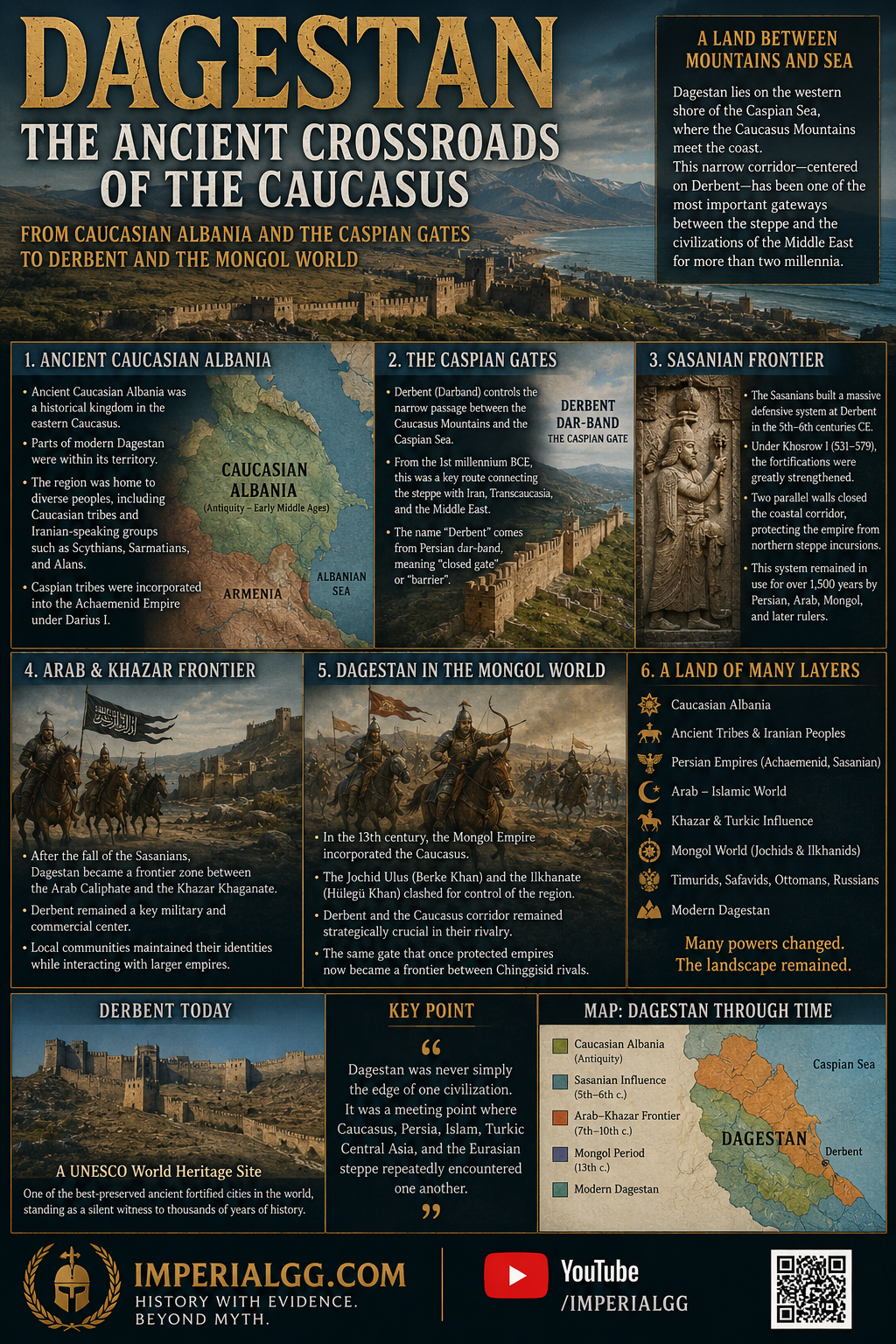
From Caucasian Albania and the Caspian Gates to Derbent and the Mongol World
By Altanbagana Baatar
DBA Candidate| Independent Historian
ImperialGG Historical Research Seriers
11 August 2026
From Caucasian Albania to Derbent
Modern Dagestan occupies a strategically important position on the western shore of the Caspian Sea, where the eastern Caucasus approaches the coast and leaves only a narrow corridor between the mountains and the sea. This geography made the region one of the principal gateways between the Eurasian steppe to the north and the civilizations of Transcaucasia, Iran, and the Middle East to the south. The history of Dagestan is therefore best understood not as the history of a single ancient people, but as the history of a frontier landscape repeatedly incorporated into different political, linguistic, and cultural systems.[1]
Ancient Dagestan and Caucasian Albania
The historical geography of Dagestan is closely connected with the ancient kingdom commonly known as Caucasian Albania. This Albania should not be confused with the modern Republic of Albania in the Balkans. Ancient Caucasian Albania occupied parts of the eastern Caucasus, and the territory of modern Dagestan formed part of this wider historical region.[2]
The population of the eastern Caucasus was never ethnically uniform. Iranian-speaking peoples and northern Iranian groups, including Scythians, Sarmatians, and later Alans, interacted with the indigenous populations of the Caucasus from antiquity onward. Persian imperial influence also reached the region at an early date. Encyclopaedia Iranica notes that Caspian tribes inhabiting Dagestan were incorporated into the Achaemenid administrative world under Darius I, while subsequent centuries brought further interaction between the eastern Caucasus and Iranian political and cultural centers.[3]
This does not mean that the people of modern Dagestan can simply be identified as “Iranian.” Modern Dagestan contains numerous distinct ethnolinguistic communities, and the ancient populations of the region cannot be equated directly with any single modern nationality. What can be demonstrated is a long history of interaction between Caucasian peoples, Iranian-speaking populations, steppe societies, and successive imperial powers.
The Caspian Gates
The geographical key to this history is Derbent.
Located on the narrow coastal passage between the Caucasus Mountains and the Caspian Sea, Derbent controlled one of the most important north–south routes in Eurasia. Archaeological evidence indicates defensive activity at the site from at least the first millennium BCE, while Greek and Roman authors knew the area in connection with the so-called Albanian Gates or Caspian Gates.[4]
The importance of the location was straightforward. Armies and migrating peoples moving between the northern steppe and the lands south of the Caucasus could either cross the mountains or pass through this narrow corridor. Whoever controlled Derbent therefore possessed a strategic gateway between two very different geographical worlds.
The modern name Derbent derives from Persian dar-band, generally understood in relation to the concepts of “gate,” “barrier,” or “closed passage.” The name itself reflects the Persianate historical environment in which the city’s great defensive system was developed.[5]
The Sasanian Frontier
The most important transformation of Derbent occurred under the Sasanian Empire.
During the fifth and sixth centuries CE, the Sasanians developed a major defensive system along the northern frontier of their empire. At Derbent, two massive parallel walls extended from the Caspian shore toward the mountain citadel, effectively closing the coastal corridor. The wider defensive system was intended to protect the settled territories south of the Caucasus from incursions originating from the northern steppe.[6]
Under Khosrow I (r. 531–579), the Sasanian state substantially strengthened the fortifications of the region. Derbent became part of a broader system of frontier defense that connected the Caspian coast with the Caucasus mountains.
UNESCO describes the Derbent complex as one of the most significant surviving components of the Sasanian northern defensive system. The fortifications continued to be used and modified by successive Persian, Arab, Mongol, Timurid, and other governments for approximately fifteen centuries.[7] Thus, Derbent was never merely a local fortress. It was an imperial frontier installation positioned at one of the most important strategic passages in Eurasia.
Arab and Khazar Worlds
The political importance of Dagestan continued after the fall of the Sasanians.
During the early Islamic period, the Caucasus became a major zone of competition between the Arab Caliphate and the Khazar Khaganate. Derbent served as an important frontier and military center, while the surrounding highlands and steppe approaches remained politically fragmented.
The region’s strategic position meant that political control was often layered rather than absolute. Local rulers and communities interacted with larger imperial powers while maintaining their own institutions and identities. This pattern would remain characteristic of Dagestan throughout the medieval period. The result was a region where Persian, Arab-Islamic, Turkic, Caucasian, and steppe traditions repeatedly encountered one another.
Dagestan in the Mongol World
The Mongol conquest introduced another major political layer. During the thirteenth century, Mongol armies entered the Caucasus and northern Caspian region. The Mongol expansion did not erase the existing geographical importance of Dagestan; instead, it incorporated the region into a much larger imperial system connecting the Eurasian steppe with Iran and the Middle East.
Derbent became particularly important during the struggles between the competing branches of the Chinggisid dynasty. The Jochid ulus, ruled by Berke Khan, regarded territories in and around the Caucasus as part of its sphere of dynastic interests, while Hülegü’s establishment of the Ilkhanate created a rival Chinggisid power to the south.[8]
The resulting conflict between Berke and Hülegü in the 1260s transformed the Caucasus into one of the principal fault lines of the emerging Chinggisid political order. The strategic importance of Derbent was therefore renewed: the same corridor that had once separated the Sasanian world from the northern steppe now became a frontier between rival Mongol dynasties.
This is one reason the history of Dagestan cannot be separated from the broader history of the Mongol Empire.
A Landscape of Overlapping Histories
The later history of Dagestan continued this pattern. Turkic-speaking groups expanded their influence in the region; Persian and Islamic cultural traditions remained important; local Caucasian languages survived; and successive political powers competed for control of the Caspian corridor.
Modern Dagestan consequently represents one of the clearest examples of a historical landscape that cannot be reduced to a single ethnic or linguistic identity. Its ancient inhabitants were not simply “Dagestani” in the modern sense. Caucasian Albania was not modern Albania. The presence of Iranian cultural influence does not make all modern Dagestanis Iranian. And the later arrival or expansion of Turkic-speaking populations does not erase the older Caucasian layers of the region.
The historical continuity lies not in the survival of one unchanged people, but in the enduring importance of the landscape itself. For more than two millennia, the narrow passage at Derbent connected the Caspian Sea, the Caucasus, the Iranian plateau, and the Eurasian steppe. Empires changed. Languages changed. Political borders changed. Populations moved and interacted. But the corridor remained.
Conclusion
The history of Dagestan is therefore best understood as the history of a Caucasian crossroads. From the world of Caucasian Albania and the ancient Caspian tribes, through Achaemenid and Sasanian influence, the Arab–Khazar frontier, the medieval Islamic world, and finally the competing Chinggisid powers of the Mongol age, the region repeatedly connected north and south.
At the center of this geography stood Derbent—the Caspian Gate. Its walls were built to control movement across the Caucasus. Its history demonstrates why geography can sometimes be more enduring than political power.
Dagestan was never simply the edge of one civilization.
It was a meeting point where Caucasus, Persia, Islam, Turkic Central Asia, and the Eurasian steppe repeatedly encountered one another. That is the deeper historical story of Dagestan.
ImperialGG.COM
History With Evidence. Beyond Myth.
Footnotes
[1] Fridrik Thordarson and Gadzhi Gamzatovich Gamzatov, “Dāḡestān,” Encyclopaedia Iranica. The article emphasizes Dagestan’s long cultural, linguistic, and political relationship with Persia and identifies the region with ancient Albania.
[2] On the historical geography of Caucasian Albania and Dagestan, see Encyclopaedia Iranica, “Dāḡestān.” The term “Caucasian Albania” refers to the ancient eastern Caucasian polity and is entirely distinct from the Balkan state of Albania.
[3] Encyclopaedia Iranica, “Dāḡestān,” discusses the presence of northern Iranian peoples, including Scythians, Sarmatians, and Alans, as well as the incorporation of Caspian tribes into the Achaemenid imperial sphere.
[4] UNESCO, “Citadel, Ancient City and Fortress Buildings of Derbent.” Archaeological evidence indicates defensive activity at Derbent from the first millennium BCE; classical authors associated the location with the Albanian/Caspian Gates.
[5] UNESCO explains the modern name Derbent through Persian dar (“gate”) and band in connection with the great fortified barrier constructed under the Sasanians.
[6] UNESCO, “Citadel, Ancient City and Fortress Buildings of Derbent.” The Sasanian fortifications consisted of parallel walls extending from the Caspian coast toward the mountain citadel and formed part of the empire’s northern defensive system.
[7] UNESCO World Heritage Committee, Decision 27 COM 8C.29. The decision recognizes Derbent’s strategic role since the first millennium BCE and the continued use of its Sasanian defensive structures by Persian, Arab, Mongol, and Timurid governments.
[8] For the Mongol-period transformation of the Caucasus and the rivalry between the Jochid and Ilkhanid branches of the Chinggisid dynasty, see the broader scholarship on the Golden Horde and Ilkhanate. Derbent’s strategic role as the Caspian corridor remained important under Mongol rule, consistent with UNESCO’s documentation of continued Mongol use of the fortification system.