
MONGOL INTELLIGENCE, GEOGRAPHICAL KNOWLEDGE, AND OPERATIONAL PLANNING IN THE KHWARAZMIAN CAMPAIGN
By Altanbagana Baatar
DBA Candidate| Independent Historian
ImperialGG Historical Research Seriers
15 November 2026
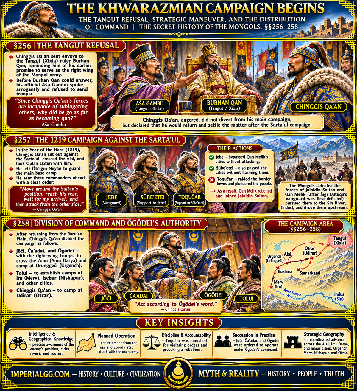
THE STRATEGIC SIGNIFICANCE OF THE SECRET HISTORY OF THE MONGOLS, §§256–258
An academic study of the Tangut alliance, the Jebe–Sübe’etei manoeuvre, and the coordinated advance across Transoxiana and Khwarazm
ABSTRACT
Sections 256–258 of The Secret History of the Mongols provide significant evidence for the Mongol army’s geographical awareness, intelligence-informed planning, operational coordination, and command discipline during the opening phase of the Khwarazmian campaign. Section 256 records the request sent to the Tangut ruler Burqan to fulfil his earlier promise to serve as the right wing of Chinggis Qan’s army. The refusal, voiced by Aša Gambu before Burqan could answer, reveals the political fragility of the Mongol–Tangut relationship. Section 257 describes the 1219 campaign across the Alai, the appointment of Ötčigin Noyan to supervise the main base camp, and the advance of Jebe, Sübe’etei, and Toqučar. Their mission was to move around the Sultan’s position, reach his rear, and coordinate an attack with Chinggis Qan’s main force. The chronicle distinguishes between Jebe and Sübe’etei, who passed the cities of Qan Melik without attacking them, and Toqučar, who raided the border settlements and provoked Qan Melik’s rebellion. The resulting battle, the defeat of Šigi Qutuqu’s vanguard, and the subsequent rear attack are followed by the pursuit toward the Šin River, identified by de Rachewiltz as the Indus. Section 258 then records the division of operational responsibilities among Jöči, Ča’adai, Ögödei, Tolui, and Chinggis Qan, with the Amu Darya, Ürünggeči, Iru, Isebur, and Udirar forming the geographical framework of the campaign. This article argues that the narrative reveals a military system based on advance intelligence, geographical assessment, route selection, restraint toward selected settlements, coordinated encirclement, and clearly assigned command responsibilities.
Keywords: Mongol Empire; Chinggis Qan; Jebe; Sübe’etei; Toqučar; Šigi Qutuqu; Qan Melik; Jalaldin Soltan; Khwarazm; Amu Darya; Urgench; Merv; Nishapur; Otrar; military intelligence; operational planning.
INTRODUCTION
The opening stages of the Mongol campaign against the Sarta’ul, or Khwarazmian, realm in 1219 are often discussed in terms of the speed and destructive capacity of Mongol cavalry. Sections 256–258 of The Secret History of the Mongols, however, reveal a more complex military system. They describe not simply the movement of mounted forces across vast distances but also the deliberate selection of routes, the identification of enemy positions, the avoidance of certain cities, the coordination of separate military columns, and the assignment of responsibilities according to geographical objectives.
The narrative begins with Chinggis Qan’s attempt to secure Tangut military assistance. It then turns to the advance of Jebe, Sübe’etei, and Toqučar, whose mission was to move around the Sultan’s position and attack from the rear once the main Mongol army arrived. The distinction between their conduct is especially revealing: Jebe and Sübe’etei bypassed the cities of Qan Melik without attacking them, whereas Toqučar independently raided border towns and plundered the local population. This action provoked Qan Melik to rebel and join Jalaldin Soltan. The chronicle thus records not only a successful military manoeuvre but also the consequences of violating the commander’s operational instructions.
Angkor Database+1
Section 258 extends the geographical picture. Chinggis Qan directed Jöči, Ča’adai, and Ögödei across the Amui River, identified as the Amu Darya or Oxus, toward Ürünggeči, the city of Urgench. Tolui was assigned the cities of Iru and Isebur, identified in the translator’s notes as Merv and Nishapur, while Chinggis Qan himself established his camp at Udirar, identified as Otrar. These assignments demonstrate that the campaign was organized through separate but coordinated axes of advance.
Angkor Database+1
The central argument of this article is that §§256–258 provide evidence of Mongol operational planning grounded in geographical knowledge and the deliberate management of military movement. Although the chronicle does not explicitly describe a formal intelligence service or identify individual spies, its detailed account of routes, enemy positions, river crossings, cities, and the planned convergence of separate forces strongly suggests the importance of information gathering and geographical assessment in Mongol strategy.
1. THE TANGUT ALLIANCE AND THE REFUSAL OF MILITARY ASSISTANCE — §256
Before proceeding with the campaign against the Sarta’ul, Chinggis Qan sent envoys to Burqan, the ruler of the Tangut people. The message reminded Burqan of his previous promise to serve as the right wing of Chinggis Qan’s army. Since the Sarta’ul had broken the Qan’s “golden halter,” Chinggis Qan had set out to call them to account and expected Burqan to fulfil his earlier commitment by joining the campaign as the right wing.
Angkor Database
The expression “golden halter” is a political metaphor for the authority and obligations established between rulers. In this context, the Tangut ruler’s earlier promise was not simply an expression of friendship. It implied a military obligation to support the Mongol campaign. The request for assistance therefore tested whether the Tangut court would honour the political relationship it had previously accepted.
Before Burqan could answer, however, Aša Gambu intervened. He declared: “Since Chinggis Qa’an’s forces are incapable of subjugating others, why did he go as far as becoming qan?”
Angkor Database
Aša Gambu refused to dispatch auxiliary troops and sent the envoys back with arrogant words. The chronicle specifically states that he spoke before Burqan could utter a word. This detail must be preserved: the refusal and insulting statement are attributed directly to Aša Gambu, not to Burqan personally.
Figure 1. The Tangut or Western Xia polity and its historical setting. These images provide context for the political and geographical position of Burqan’s realm; they are not contemporary illustrations of the diplomatic encounter in §256.
Chinggis Qan was angered by Aša Gambu’s response. He considered the possibility of immediately diverting troops against the Tanguts but decided not to interrupt the campaign against the Sarta’ul. He declared that, if protected by Eternal Heaven, he would return at the end of the campaign and settle the matter. The reference to returning with the “golden reins” connects this statement to the earlier “golden halter” metaphor. It also indicates that Chinggis Qan regarded the Tangut question as an unresolved political and military issue.
Angkor Database
This passage reveals an important element of Mongol strategic decision-making: the ability to distinguish between an immediate military objective and a secondary conflict that could be postponed. Chinggis Qan did not allow Aša Gambu’s provocation to divert the main army from its planned campaign. The decision to defer retaliation suggests a hierarchy of objectives and a conscious effort to preserve operational focus.
2. THE 1219 CAMPAIGN: THE CROSSING OF THE ALAI AND THE ORGANIZATION OF THE ADVANCE — §257
Section 257 explicitly dates the campaign to the Year of the Hare, 1219. Chinggis Qan set out against the Sarta’ul, crossing the Alai. Among the royal women, he took Qulan Qatun with him. He entrusted Ötčigin Noyan, one of his younger brothers, with responsibility for the main base camp before moving forward with the army.
Angkor Database
The reference to Ötčigin Noyan is significant. The main base camp was not left without a designated commander while the Great Qan advanced into enemy territory. The assignment indicates that the campaign required a division between the mobile field army and the logistical and administrative organization remaining behind. Ötčigin’s responsibility helped maintain continuity between the advancing forces and the central base.
Figure 2. The Alai region and its mountain corridors. The Alai crossing was an important geographical element in the Mongol advance toward the Sarta’ul territories. The image illustrates the terrain, not the precise medieval route.
Chinggis Qan then sent three commanders ahead in a clearly defined sequence:
Jebe was appointed as the vanguard.
Sübe’etei was sent in support of Jebe.
Toqučar was sent in support of Sübe’etei.
Their mission was to move around the Sultan’s position, emerge on the opposite side, wait for Chinggis Qan’s arrival, and attack the enemy from the rear. De Rachewiltz explains that “the Sultan” in this passage refers to Jalaldin Soltan, who is named later in the same section.
Angkor Database
The instruction is important because it describes a coordinated operation rather than an independent raid. The three commanders were not simply ordered to advance as quickly as possible. They were instructed to reach a specific operational position relative to the enemy and to synchronize their attack with the arrival of the main army.
The wording of the order indicates three separate requirements:
Route selection: move around the outside of the Sultan’s position rather than directly confronting his forces.
Positioning: reach the enemy’s rear and establish a position from which a second direction of attack would be possible.
Coordination: wait for Chinggis Qan’s main force and attack when the enemy was exposed to pressure from both directions.
This is evidence of operational planning based on an understanding of the enemy’s location and the surrounding terrain. It does not, by itself, prove the existence of a centralized intelligence bureau. Nevertheless, the ability to issue such a geographically specific instruction implies access to information about the enemy’s position, the available routes, and the relationship between the different military columns.
3. THE CITIES OF QAN MELIK: GEOGRAPHICAL RESTRAINT AND THE CONSEQUENCES OF TOQUČAR’S RAID — §257
The chronicle makes an especially important distinction between the actions of Jebe, Sübe’etei, and Toqučar.
Jebe passed the cities of Qan Melik without touching them, bypassing them by the outer route. Sübe’etei followed the same route and likewise avoided attacking those cities. Toqučar, however, coming behind Sübe’etei, attacked Qan Melik’s border towns and plundered the peasants. As a consequence, Qan Melik rebelled against the Mongols and joined Jalaldin Soltan.
Angkor Database
Figure 3. The geographical setting of the Khwarazmian campaign, including the major urban centers of Transoxiana and Khwarazm. The map should be used as a regional reference; it is not a reconstruction of the exact routes taken by each Mongol column.
This distinction provides one of the clearest indications of the importance of geographical and political knowledge in the campaign. The Mongol commanders did not treat every settlement along their route as an interchangeable target. Jebe and Sübe’etei passed through the region without attacking Qan Melik’s cities. Their mission was to manoeuvre around the Sultan’s position and preserve their operational direction. Attacking the border settlements would have created an additional enemy and altered the political conditions of the campaign.
Toqučar’s decision had precisely that consequence. His raids transformed Qan Melik from a ruler whose cities had been bypassed into an active opponent who joined Jalaldin Soltan. The chronicle explicitly links the attack on the towns to Qan Melik’s rebellion. The episode therefore demonstrates that the conduct of a military commander could change the political alignment of a regional ruler and thereby affect the larger campaign.
The contrast is particularly revealing:
Commander | Action recorded in the chronicle | Operational consequence |
|---|---|---|
Jebe | Bypassed Qan Melik’s cities without attacking them | Maintained the planned route |
Sübe’etei | Followed Jebe and avoided attacking the cities | Preserved the coordinated advance |
Toqučar | Raided border towns and plundered peasants | Provoked Qan Melik’s rebellion and alliance with Jalaldin Soltan |
This comparison shows that military success depended not only on combat ability but also on restraint and obedience to the strategic purpose of the mission. A commander who attacked every settlement in his path could create new enemies and disrupt the intended operation. Toqučar’s action was therefore not simply an isolated act of plunder; it changed the political and military environment in which the campaign was being conducted.
The chronicle does not state that Jebe and Sübe’etei were specifically ordered to spare Qan Melik’s cities in a separate written instruction. It records their conduct and contrasts it with Toqučar’s. The most cautious interpretation is that their restraint was consistent with the larger order to bypass the Sultan’s position and reach the rear, whereas Toqučar’s raid represented an unauthorized deviation from the intended operation.
4. THE BATTLE AGAINST JALALDIN SOLTAN AND QAN MELIK: THE DEFEAT OF ŠIGI QUTUQU AND THE REAR ATTACK
After Qan Melik joined Jalaldin Soltan, the two leaders moved against Chinggis Qan. The Mongol ruler sent Šigi Qutuqu ahead as the vanguard of his own force. Jalaldin Soltan and Qan Melik engaged Šigi Qutuqu’s troops and defeated them. They continued advancing and approached Chinggis Qan’s main force. At that moment, however, Jebe, Sübe’etei, and Toqučar arrived from behind Jalaldin Soltan and Qan Melik, attacked them, and inflicted a decisive defeat.
Angkor Database
Figure 4. An artistic reconstruction of a Mongol cavalry engagement. The image illustrates the tactical concept of a rear attack and coordinated pressure from different directions; it is not a contemporary depiction of the battle described in §257.
The sequence is important. Šigi Qutuqu’s vanguard was defeated in the initial engagement, and the enemy advanced close to Chinggis Qan. The decisive reversal came when the three commanders who had been sent ahead appeared behind the opposing force. The operation thus fulfilled the central purpose of their original assignment: to reach the enemy’s rear and attack in coordination with the main army.
The battle demonstrates the danger of advancing against a force without securing its rear. Jalaldin Soltan and Qan Melik had defeated the Mongol vanguard but had not neutralized the separate Mongol column moving around their position. Their forward advance exposed them to an attack from behind. The Mongol plan therefore transformed an initial tactical setback into a larger defeat of the enemy.
It is also necessary to avoid presenting the victory as an unbroken success by every Mongol unit. The chronicle explicitly records Šigi Qutuqu’s defeat. This detail makes the subsequent rear attack more significant, because it shows how the Mongol command structure could respond to a difficult battlefield situation through the coordinated action of separate forces.
5. THE PREVENTION OF ENEMY CONCENTRATION: BUKHARA, SAMARKAND, OTRAR, AND THE PURSUIT TO THE INDUS
Following the defeat of Jalaldin Soltan and Qan Melik, the Mongol forces prevented the opposing army from joining together in the cities of Buqar, Semisgab, and Udarar. De Rachewiltz’s notes identify these as Bukhara, Samarkand, and Otrar respectively, while correcting the form Semisgab to Semisgen. The same notes identify the Šin River with the Indus River.
Angkor Database
Figure 5. The major urban centers of Transoxiana: Bukhara, Samarkand, and Otrar. Their importance lay not only in their political status but also in their position within the region’s routes, settlement networks, and commercial geography.
The importance of these cities lies in their strategic relationship to the movement of armies. Bukhara, Samarkand, and Otrar were major centers in the region. If Jalaldin Soltan and Qan Melik had been able to reach and concentrate their forces in these cities, they might have been able to reorganize their resistance. The Mongol pursuit prevented that concentration and pushed the defeated forces farther toward the Šin River.
The chronicle records that the Mongols pursued the Sarta’ul to the Šin River. Under pressure, many of the Sarta’ul soldiers threw themselves into the river and drowned. Jalaldin Soltan and Qan Melik escaped by moving upstream along the river. Chinggis Qan then advanced upstream, plundered Batkesen, and reached the Eke Stream and the Ge’ün Stream, where he established his camp on the Baru’an Plain.
Angkor Database
De Rachewiltz identifies the Šin River with the Indus and explains the place-name Batkesen in connection with Badakhshan, a region known for its precious stones. These identifications are important because they help place the narrative within the broader geography of Central and South Asia.
Angkor Database
Figure 6. The Indus basin, Badakhshan, and the Amu Darya region. These geographical images help illustrate the scale of the campaign and the relationship between river corridors, mountain routes, and urban centers.
The pursuit toward the Indus is especially significant in the context of Mongol geographical knowledge. The army operated across a vast landscape that included mountain corridors, river systems, agricultural settlements, fortified cities, and open steppe. Its movements required an understanding of the relationship between these different environments. The chronicle does not explain how every route was discovered or which informants supplied the information, but the campaign’s recorded movements demonstrate that geographical knowledge was essential to its execution.
6. THE PUNISHMENT OF TOQUČAR: COMMAND DISCIPLINE AND THE CONTROL OF MILITARY VIOLENCE
After establishing camp on the Baru’an Plain, Chinggis Qan sent Bala of the Jalayir to pursue Jalaldin Soltan and Qan Melik. He then praised Jebe and Sübe’etei, recalling Jebe’s former name, Jirqo’adai, and his transfer from the Tayici’ut to Chinggis Qan’s service. The recognition of these two commanders was followed by a direct accusation against Toqučar: he had attacked Qan Melik’s border towns of his own initiative and caused Qan Melik to rebel.
Angkor Database
Chinggis Qan declared that Toqučar should be executed under the law. However, he ultimately did not put him to death. Instead, he severely reprimanded him, punished him, and demoted him from his military command.
Angkor Database
This episode is important for understanding Mongol military discipline. Toqučar had participated in the rear attack that helped defeat Jalaldin Soltan and Qan Melik. Nevertheless, his contribution to the battle did not erase the consequences of his earlier unauthorized raid. Chinggis Qan evaluated the commander not solely by his battlefield performance but also by whether he had followed the strategic purpose of the mission.
The punishment demonstrates that the Mongol command system placed considerable importance on the relationship between operational orders and political consequences. Toqučar’s attack had created an additional enemy, complicated the campaign, and contributed to the formation of an opposing alliance. The demotion therefore served as a warning that military initiative could not be exercised without regard to the ruler’s larger strategic objectives.
7. THE DIVISION OF THE CAMPAIGN: AMU DARYA, URGENCH, MERV, NISHAPUR, AND OTRAR — §258
Section 258 reveals another dimension of the Mongol operational system: the deliberate division of military responsibilities among the members of the ruling family.
After returning from the Baru’an Plain, Chinggis Qan sent three of his sons—Jöči, Ča’adai, and Ögödei—with the troops of the right wing across the Amui River, identified by de Rachewiltz as the Amu Darya or Oxus, to establish their camp at Ürünggeči, identified as Urgench.
Angkor Database

Figure 7. The Amu Darya, historically known as the Oxus. Its crossing was a major geographical element in the Mongol advance toward the Khwarazmian urban centers.
Chinggis Qan assigned Tolui to establish camps at Iru, Isebur, and other cities. De Rachewiltz identifies Iru as Merv and Isebur as Nishapur. Chinggis Qan himself established his camp at Udirar, identified as Otrar. The distribution of these assignments is significant: the Mongol army was not advancing as a single undifferentiated mass but was divided into separate operational groups with clearly designated objectives.
Angkor Database
Figure 8. The principal cities named in §258: Urgench, Merv, Nishapur, and Otrar. Their identification follows de Rachewiltz’s explanatory notes. The images show their modern archaeological or historical settings, not their appearance during the campaign.
The geographical assignments can be summarized as follows:
Commander | Assigned force and route | City or region | Modern identification |
|---|---|---|---|
Jöči, Ča’adai, Ögödei | Right-wing troops across the Amui River | Ürünggeči | Urgench |
Tolui | Separate force assigned to multiple cities | Iru | Merv |
Tolui | Same assigned force | Isebur | Nishapur |
Chinggis Qan | Main command and camp | Udirar | Otrar |
The three princes reached Ürünggeči with their troops assembled and sent a message to their father asking whose command they should follow. Chinggis Qan replied that they should act according to the orders of Ögödei. This is a direct statement about command hierarchy in the field. The three brothers were operating together, but the Great Qan designated one of them as the authority whose instructions the others should follow.
Angkor Database
This decision should be understood in relation to the succession discussion in §255, where Ögödei had been proposed as the successor. Section 258 demonstrates that the political designation was accompanied by a practical role in command. Nevertheless, the passage is specifically about military authority during the campaign. It should not be described as the formal enthronement of Ögödei, which occurred later.
The distribution of forces across Urgench, Merv, Nishapur, and Otrar also reveals a broad geographical conception of the campaign. The Mongol command was concerned with multiple cities and routes at the same time. This was essential for preventing the enemy from concentrating forces, securing strategic centers, and maintaining communication between separate columns.
8. MONGOL INTELLIGENCE AND GEOGRAPHICAL KNOWLEDGE: AN INTERPRETATION OF §§256–258
The strongest evidence for Mongol geographical awareness in these sections lies in the relationship between the orders issued and the actions subsequently recorded.
First, Chinggis Qan knew that the Sultan’s position could be bypassed and attacked from the rear. He did not order the vanguard to engage the enemy immediately. Instead, he instructed Jebe, Sübe’etei, and Toqučar to move around the enemy, reach the rear, and wait for the main force. This required an understanding of the enemy’s position and the routes available for reaching the rear.
Second, Jebe and Sübe’etei distinguished between the Sultan’s military position and the cities belonging to Qan Melik. Their decision to pass those cities without attacking them suggests an awareness that unnecessary destruction could create new political enemies and interfere with the planned manoeuvre. Toqučar’s failure to maintain this restraint demonstrates the consequences of ignoring the wider political geography.
Third, the Mongol army’s pursuit toward the Šin River, the movement upstream, and the arrival at Batkesen, the Eke Stream, and the Ge’ün Stream demonstrate the importance of river systems and geographical corridors. These place-names are not decorative details. They are part of the narrative’s account of military movement and the establishment of camps.
Fourth, the deployment in §258 reveals that the command understood the geographical relationship between the Amu Darya and the major urban centers of Khwarazm and Transoxiana. Jöči, Ča’adai, and Ögödei were assigned to Urgench, Tolui to Merv and Nishapur, and Chinggis Qan to Otrar. Such a division required the ability to coordinate separate forces across substantial distances.
The chronicle does not identify the individuals who gathered intelligence, the methods by which routes were surveyed, or the precise form of Mongol reconnaissance. Therefore, it would be inaccurate to claim that §§256–258 document a formal intelligence agency. However, they provide evidence of an army whose operations depended on information about enemy positions, political allegiances, routes, settlements, and terrain. The most defensible conclusion is that Mongol military success rested in part on an effective system of intelligence gathering and geographical assessment, even though the specific institutional mechanisms are not described in these passages.
CONCLUSION
Sections 256–258 of The Secret History of the Mongols demonstrate that the Mongol campaign against the Khwarazmian realm was organized through a sophisticated combination of political calculation, geographical awareness, intelligence-informed manoeuvre, and centralized command.
The refusal of Aša Gambu to provide Tangut auxiliary troops did not immediately divert Chinggis Qan from his principal objective. Instead, the Great Qan postponed the Tangut question and continued the campaign against the Sarta’ul. This decision reveals a clear hierarchy of strategic priorities.
The advance of Jebe, Sübe’etei, and Toqučar provides particularly strong evidence of operational planning. Their mission was to bypass the Sultan’s position, reach his rear, and coordinate their attack with Chinggis Qan’s main force. Jebe and Sübe’etei passed the cities of Qan Melik without attacking them, while Toqučar’s unauthorized raids provoked Qan Melik to join Jalaldin Soltan. The subsequent defeat of Šigi Qutuqu’s vanguard and the decisive rear attack demonstrate the effectiveness of the coordinated manoeuvre, while Toqučar’s punishment illustrates the importance of obedience to strategic orders.
The geographical sequence—from the Alai crossing to the cities of Bukhara, Samarkand, and Otrar, then toward the Šin or Indus River, and finally to the Amu Darya and Urgench—reveals the scale of the campaign. The assignments to Jöči, Ča’adai, Ögödei, Tolui, and Chinggis Qan further demonstrate how the Mongol command divided its forces among different urban and riverine objectives.
The historical importance of these passages therefore extends beyond the speed of Mongol cavalry or the destruction of enemy armies. They reveal a military system capable of distinguishing between political territories, selecting routes, avoiding unnecessary engagements, preventing enemy concentration, and coordinating separate forces across a vast geographical area. The Mongol army’s effectiveness was not simply a product of mobility; it also depended on information, geographical knowledge, disciplined execution, and the ability to plan the movements of multiple forces before they reached the battlefield.
PRIMARY SOURCES AND SCHOLARLY REFERENCES
1. Igor de Rachewiltz, translator. The Secret History of the Mongols: A Mongolian Epic Chronicle of the Thirteenth Century. Shorter edition edited by John C. Street. Western Washington University, 2015. §§256–258, pp. 178–181.
2. Urgunge Onon, translator and annotator. The Secret History of the Mongols: The Life and Times of Chinggis Khan. London and New York: RoutledgeCurzon, 2001.
– Full English translation — RoutledgeCurzon edition.
3. Igor de Rachewiltz. The Secret History of the Mongols, full scholarly edition, 3 volumes. Leiden and Boston: Brill, 2004–2013. The full commentary is particularly important for the identification of place-names, historical geography, and variant readings.
– Rachewiltz — Subject Index and scholarly references.
4. Christopher P. Atwood. Research on the Mongol Empire, Chinggisid political institutions, and the historical interpretation of the Secret History.
– Oxford Research Encyclopedia — Mongol military campaigns and the Jebe–Sübe’etei expedition.
SOURCE-CRITICAL NOTES
The Sultan: In §257, de Rachewiltz’s note identifies the Sultan in the operational order as Jalaldin Soltan, named later in the passage. This should not be confused with the Khwarazmshah Muhammad II, who appears in the broader history of the campaign.
Qan Melik: The chronicle identifies him as a separate political and military actor whose cities were bypassed by Jebe and Sübe’etei. The exact historical identification and his relationship with the Khwarazmian ruling house require comparison with Persian sources.
Toqučar: De Rachewiltz’s index notes that his identification is unclear. His role in §257 is nevertheless explicit: he raided Qan Melik’s border towns and was demoted for provoking the rebellion.
Šin River: Identified by de Rachewiltz as the Indus River.
Buqar, Semisgab, Udirar: Identified as Bukhara, Samarkand, and Otrar. De Rachewiltz notes that Semisgab is a textual error for Semisgen.
Amui River: Identified as the Amu Darya or Oxus.
Ürünggeči: Identified as Urgench, the major Khwarazmian city.
Iru and Isebur: Identified as Merv and Nishapur.
Intelligence: The article interprets the route selection and manoeuvres as evidence of intelligence-informed planning. The chronicle does not explicitly identify spies, intelligence officers, or a formal intelligence institution.
IMPERIALGG.COM — HISTORY • CULTURE • CIVILIZATION
MYTH & REALITY — HISTORY • PEOPLE • TRUTH